Input
AI-Assisted Tactical Hunt Planning
AI Hunt Planning Built Around Your Map, Wind, and Terrain
Raven Scout analyzes your selected map area, target species, hunt timing, GPS, wind, weather, weapon, method, and known locations to produce ranked setups, access routes, risk notes, and a practical tactical brief.
Now available for iOS and Android.
Planning
Ranked setups and access
Context
Wind, weather, method
Availability
App Store and Google Play live
A Hunt Plan, Not A Guess
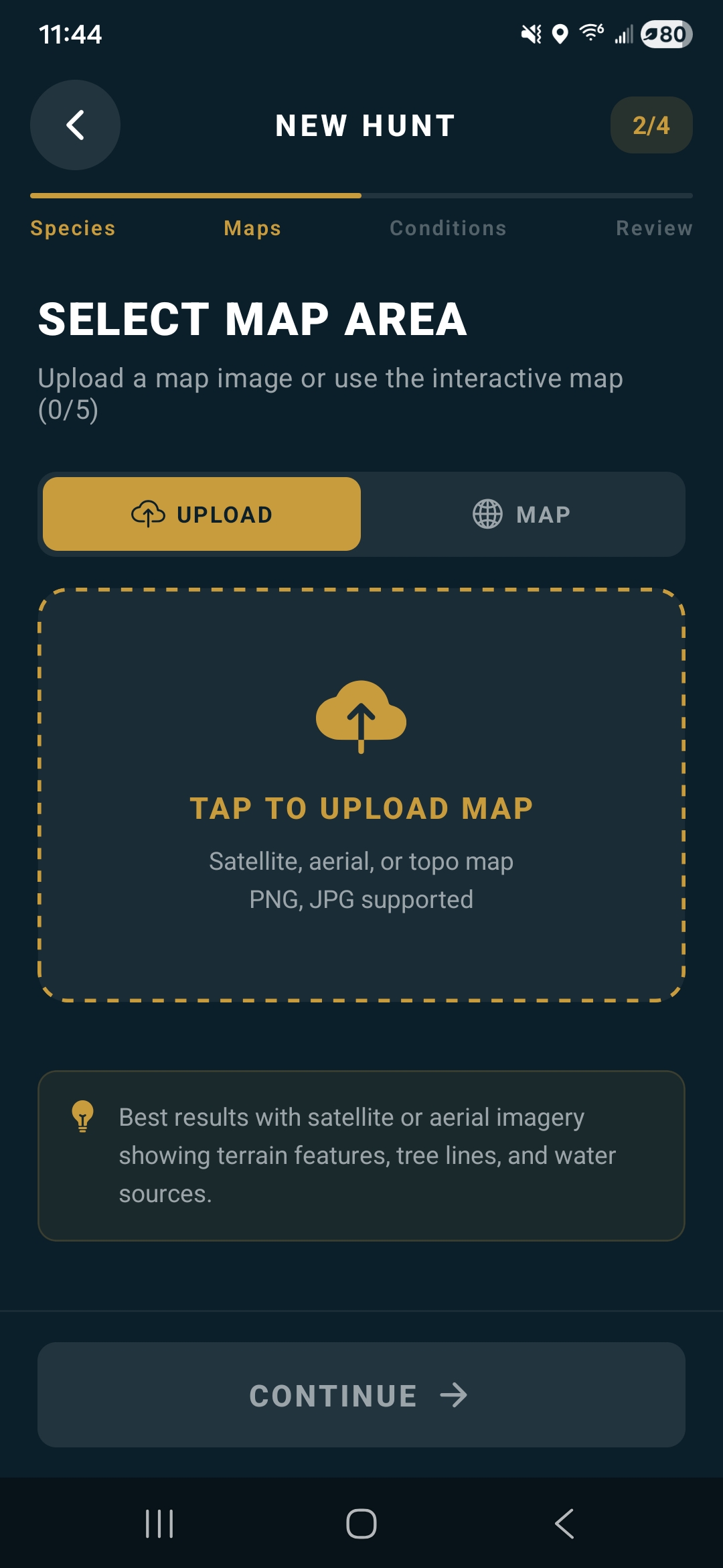
Map Input
Start with terrain
Select the hunt area in the interactive in-app map. This is the released app's only hunt-map input.
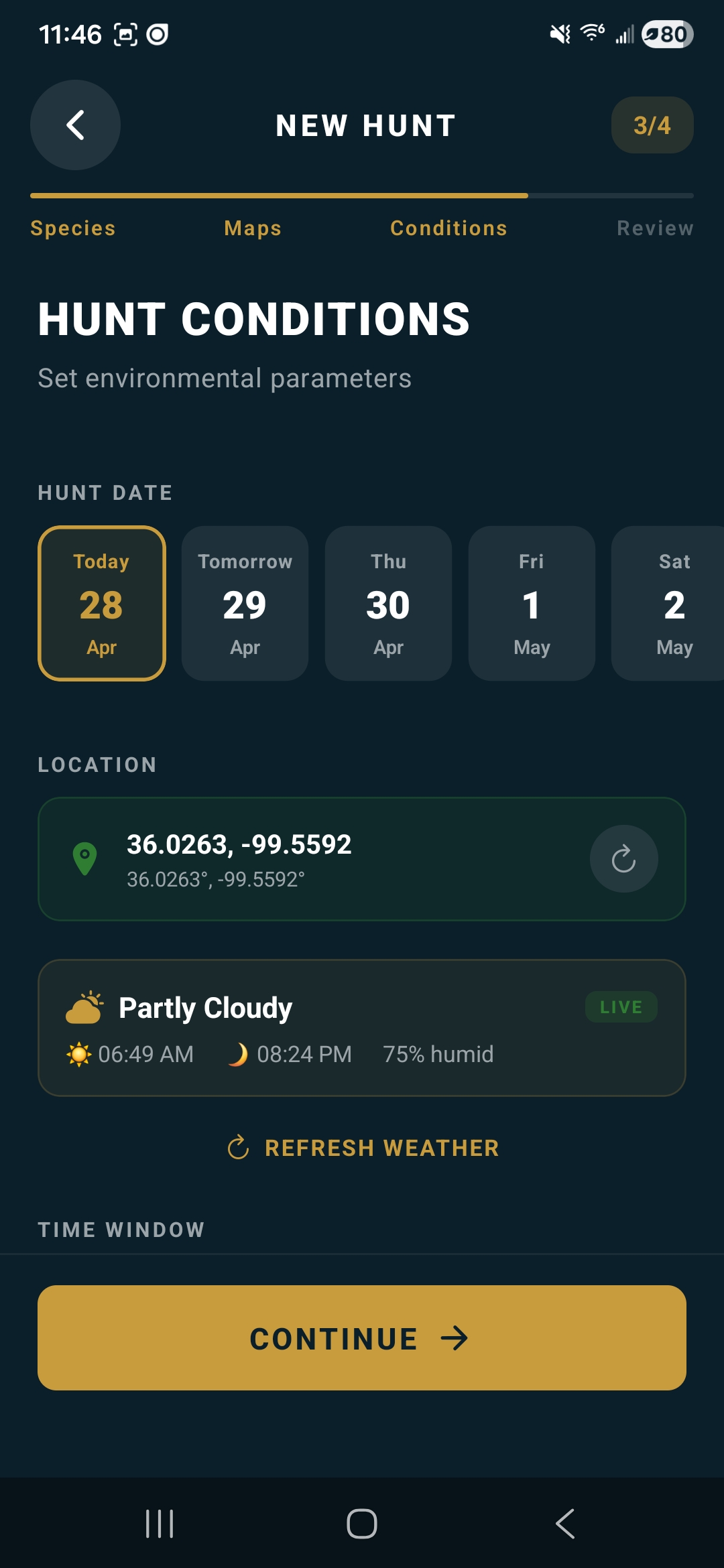
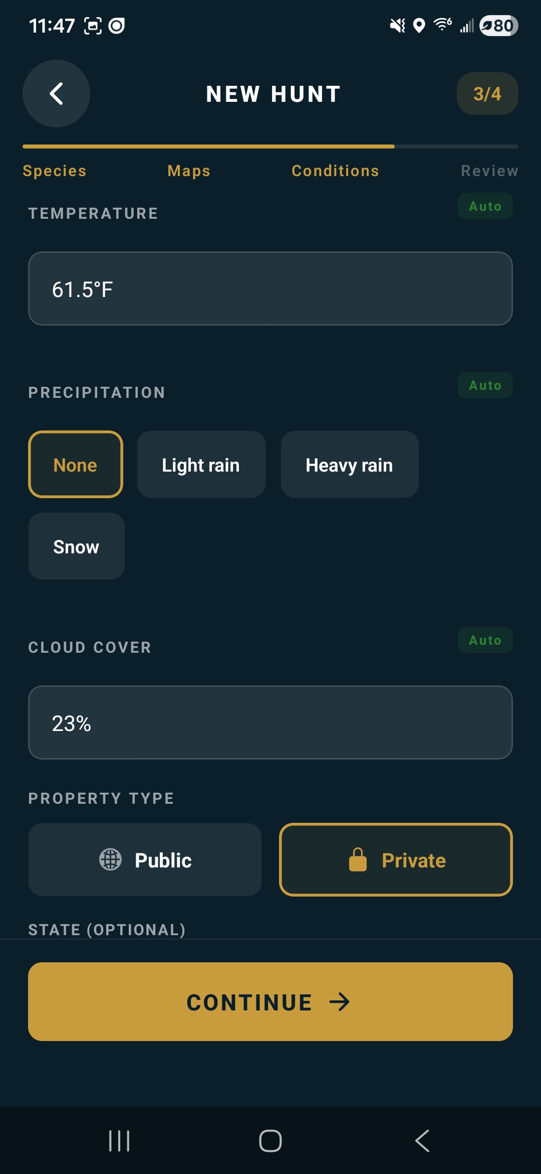
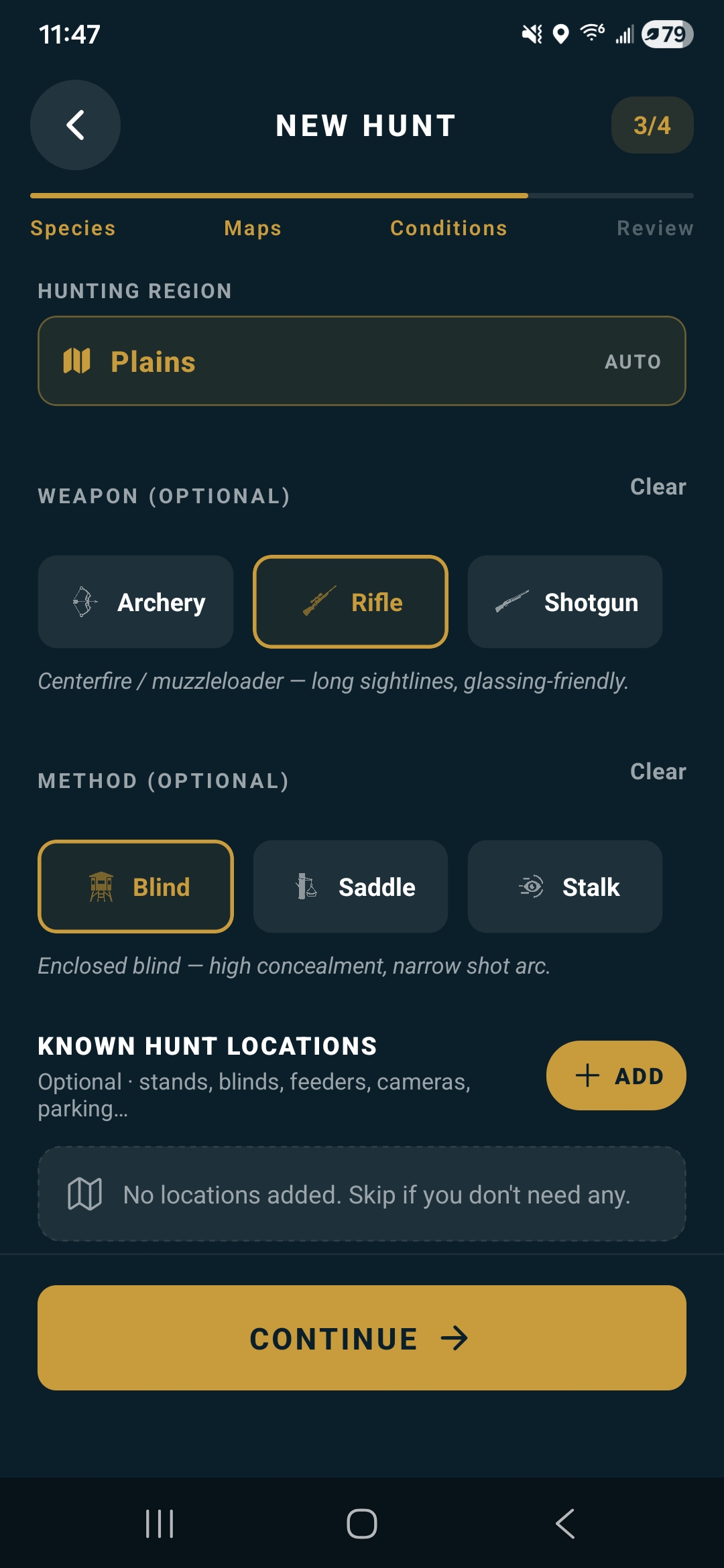
Hunt Details
Add field conditions
Set species, date, time window, GPS, wind, weather, weapon, and method. Eligible plans can also add known field locations and boundaries.
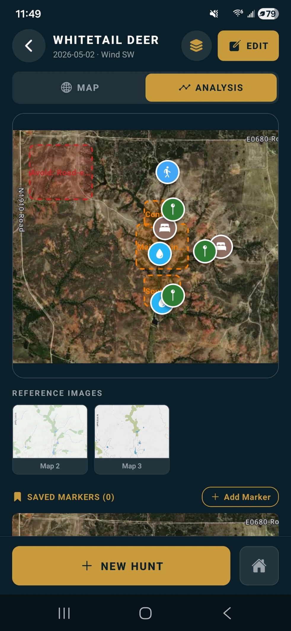
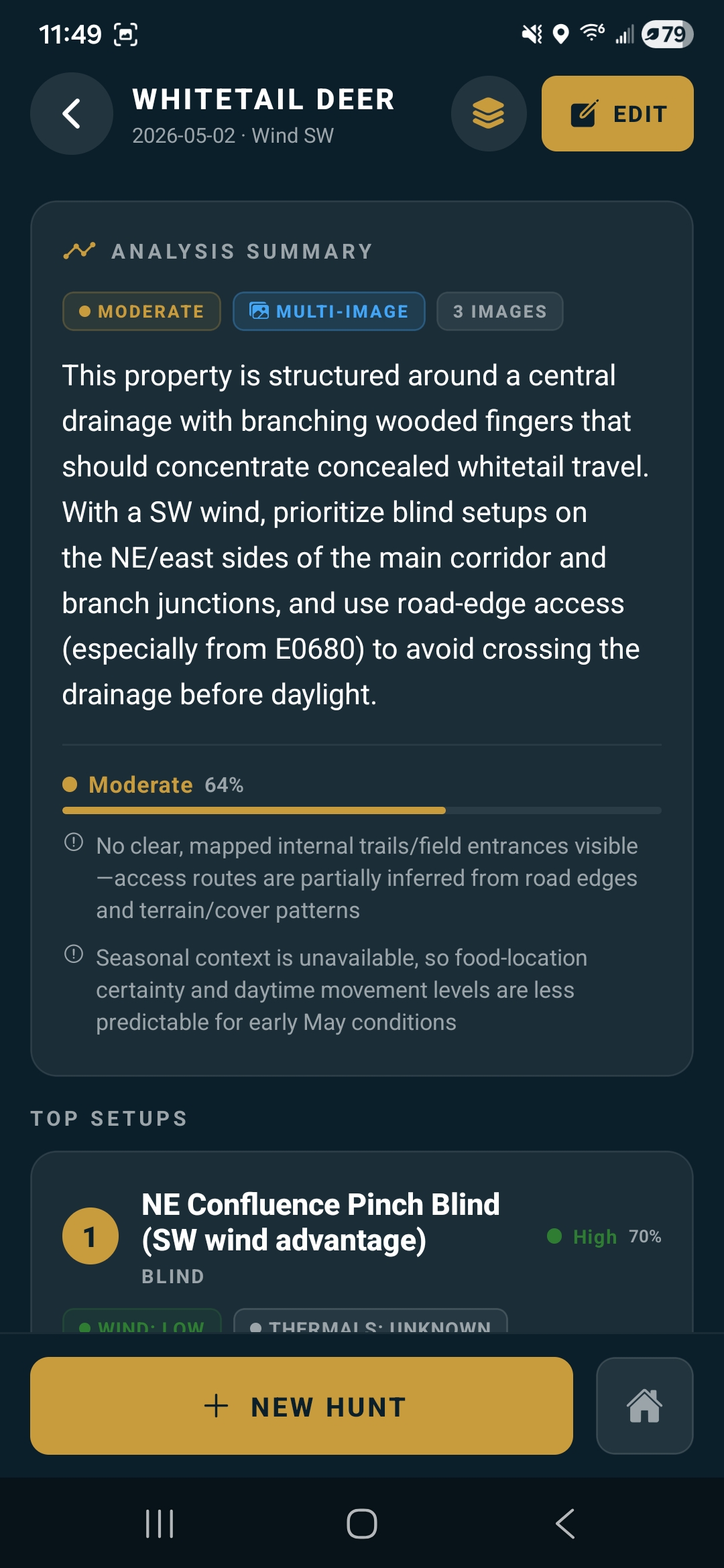
Output
Ranked recommendations
Review setup rankings, access routes, avoid zones, wind notes, and assumptions behind the plan.
Saved Hunts
Return to the plan
Saved hunts preserve the plan. Save its offline field packet before leaving service to keep a read-only map snapshot, markers, and plan details available.
Capabilities In The Field
Map-Aware Planning
Terrain intelligence before the walk in.
Raven Scout is built around practical setup planning: select the map area, add the hunt context, and use the result as one input before you move through the property.
- Hunting-map and terrain analysis with overlays and saved markers
- Ranked setups, access routes, and avoid-zone notes
- Deer, Wild Turkey, Wild Hog, Coyote, Black Bear, Moose, Elk, and Pronghorn Antelope
- Weather, wind, and time-window context included in the brief
Released Species And Plan Access
Trial
Try hunt planning
Trial provides a tier-based analysis allowance. The current in-app plan screen is the source of truth for its exact quota and included features.
Core
Expanded planning
Core provides a paid tier allowance and additional planning features. Check the current in-app plan screen and device store for the exact quota, feature access, and regional price.
Pro
More map context
Higher-plan options include live multi-image analysis and cloud backup. Check the current in-app plan screen and device store for the exact quota, feature access, and regional price.
Context The AI Uses
Field Inputs
Conditions shape the plan
Raven Scout does not treat every hunt the same. Weapon, method, wind, weather, hunt window, privacy, GPS, and target species all shape the recommendation.
Known Locations
Your fixed points matter
Eligible plans can add stands, blinds, cameras, feeders, parking, access points, and custom locations so the plan respects what they already know about the property.
How It Works
The AI evaluates terrain and hunt context.
Raven Scout examines the selected map area and field inputs to create a tactical brief with setup logic, access suggestions, risk notes, and assumptions you can verify before the hunt.
Use the plan as decision support, then verify property access, regulations, safety, and field conditions independently before acting on a recommendation.
- Complete, current inputs give the plan more useful context
- Field judgment and local verification still matter
Support And Policies
Useful links when you need details.
Review app support, privacy, release notes, data deletion, terms, and the full user manual from the Raven Scout support library.
Hunt Planning Resources
Build a Better Map-Based Plan
Read a Topographic Map
Interpret contours, ridges, drainages, saddles, benches, and access constraints.
Read guideEvaluate Wind at a Stand
Review wind cones, terrain effects, entry and exit, and backup options.
Read guideMap Funnels and Corridors
Separate possible travel structure from use confirmed by current evidence.
Read guideAnalyze Satellite Maps
Layer boundaries, access, cover, openings, water, edges, and terrain.
Read guideRaven Scout FAQ
What information does Raven Scout use to build a hunt plan?
Raven Scout uses the hunt area selected in its interactive map together with terrain, timing, GPS, wind, weather, weapon, hunt method, and target species. Eligible tiers can also use multiple in-app map captures, cloud backup, known field locations, and boundaries.
Which species does Raven Scout support?
The released app supports Deer, Wild Turkey, Wild Hog, Coyote, Black Bear, Moose, Elk, and Pronghorn Antelope.
What is included in the Raven Scout trial and subscriptions?
Raven Scout has Trial, Core, and Pro tiers with tier-based analysis quotas. Multi-image analysis and cloud backup are live plan features. Check the current in-app plan screen and device store for the exact allowance, feature access, and regional price before purchase.
What does a Raven Scout analysis return?
A plan can include ranked setups, access routes, avoid areas, saved markers, wind and timing notes, assumptions, and tactical guidance tied to the supplied map and hunt context.
Is Raven Scout available for iOS and Android?
Yes. Raven Scout is free to download from the Apple App Store and Google Play, with optional in-app subscriptions.
Does Raven Scout replace field judgment?
No. Raven Scout is planning support. Hunters must independently verify property access, boundaries, regulations, safety, weather, wind, and current field conditions.
Download Raven Scout.
Free to download on iOS and Android. Optional subscriptions add monthly analyses and plan features.